
Conservation
|
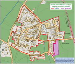
This page provides access to a Parish Council map which details:
The Conservation Area exists to retain and enhance the distinctive character of the village. In particular:
|
|
©This map is reproduced from Ordnance Survey material with the permission of the Ordnance Survey on behalf of the Controller of Her Majesty’s Stationery Office. Crown Copyright reserved. Unauthorised reproduction infringes Crown Copyright and may lead to prosecution or civil proceedings. Milton Malsor Parish Council 2008 Licence number 100044533. No responsibility is accepted for any inaccuracies. To view the high-resolution map you will need to have a copy of Adobe Reader installed on your computer; if you don't have a copy, you can download the reader from the Adobe web site.
A leaflet from South Northants Council describes the Milton Conservation Area which was first designated in 1991. The leaflet describes the area, its buildings, their setting, and their features. Although the leaflet is now a few years old, much of what is stated still stands today. This includes advice on protecting the area and some general guidance on what owners of property in the area must do. Please note that the original conservation area has been extended since the leaflet was published, and the map shown above on this page defines the area as of November 2009. Attention is drawn to requirements for work on all trees in the area and also to all trees outside the area, which are subject to tree preservation orders. If in doubt, please check with South Northants Council. Some recent additions have been made to the list of trees with preservation orders. Landowners affected will have been informed.
A leaflet from South Northants Council describes the Milton Conservation Area which was first designated in 1991. The leaflet describes the area, its buildings, their setting, and their features. Although the leaflet is now a few years old, much of what is stated still stands today. This includes advice on protecting the area and some general guidance on what owners of property in the area must do. Please note that the original conservation area has been extended since the leaflet was published, and the map shown above on this page defines the area as of November 2009. Attention is drawn to requirements for work on all trees in the area and also to all trees outside the area, which are subject to tree preservation orders. If in doubt, please check with South Northants Council. Some recent additions have been made to the list of trees with preservation orders. Landowners affected will have been informed.
This page last updated 14-04-2022